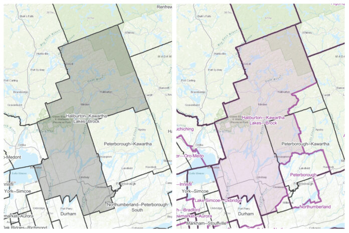
Highlands East mayor Dave Burton said his municipality is lobbying hard to ensure a proposal to split the township between two new federal riding boundaries does not occur.
Burton said he got an email from Haliburton-Kawartha Lakes-Brock (HKLB) MP Jamie Schmale after the Federal Electoral Boundaries Commission for Ontario released its suggested maps for the next election.
While Algonquin Highlands, Dysart et al, and Minden Hills would remain in HKLB, a portion of Highlands East would become part of a new Hastings-Lennox and AddingtonTyendinaga riding. The commission is undertaking public consultations this month and isn’t expected to finalize new boundaries until September 2023.
The next federal election will be in 2025. Burton said Schmale met with township representatives via Zoom Aug. 25 to say they, “absolutely wanted no part of that. Just even to set the tone of the meeting with Jamie, I said, ‘I want to be with Haliburton County. I don’t want to be split up the centre. It will make it extremely difficult to do business’.”
He added, “I’m happy with the way the boundaries are now, and we made it very clear to Jamie and his bunch.”
Burton said they are preparing documentation to send to the commission and are hopeful of getting letters of support from other County municipalities, as well as regional ones.
“I’ll certainly be looking for support to stay in Haliburton County and I do feel very positive that we are going to remain in Haliburton County,” Burton said.
Schmale said the first draft is showing “a number of fairly significant changes” for the riding.
The Highlands East split would see Gooderham and Tory Hill staying in HKLB, and Cardiff and Wilberforce heading towards the Hastings riding. He said after meeting with Highlands East, “It’s clear in their minds that they want to keep Haliburton County together for a whole bunch of valid reasons. I think that’s a fairly easy argument to make to the commission.”
He will make a public appearance at the committee hearings in late September. “I’m also encouraging organizations like the chamber of commerce, business organizations, anybody that would have a vested interest in this to write a submission to the commission,” he added. Overall, Schmale said the new riding would take in Trent Lakes, or the Buckhorn area, “which does add a bit more geography, a bit more complexity to doing the job.”
He said he will pitch the status quo, including keeping all of Highlands East and Cavan-Monaghan.
The commission released its proposed electoral map for public consultation Aug. 19.
They said it reflects population changes in the 2021 Census. Under the Canadian constitution, federal electoral districts must be reviewed after each 10-year Census to reflect population shifts.
The population of Central East Ontario – which includes the ridings of Peterborough-Kawartha, HKLB, Northumberland-Peterborough South, Hastings-Lennox and Addington, and Bay of Quinte – grew by nine per cent, from 535,322 in 2011 to 583,287 in 2021.
The commission is proposing shifted boundaries to balance the population of the districts across Central East Ontario.
The proposed HKLB, comprising a population of 120,241, would include the City of Kawartha Lakes, the Municipality of Dysart et al, the western portion of the Municipality of Highlands East, the Municipality of Trent Lakes (except for the islands of the Curve Lake First Nation), the townships of Algonquin Highlands, Brock, and Minden Hills, and a portion of the Cavan Monaghan Township. The commission is holding in-person and virtual public hearings this fall to gather comments and feedback on the proposed boundaries and electoral district names. The first virtual hearing for Central Ontario will take place on Monday, Sept. 26.
Those wanting to speak have to complete a public hearing participation form by Sept. 25. There will also be an Ontario open virtual hearing on Oct. 29. Find out more at redecoupage-redistribution-2022.ca. A map of the current (top) and proposed (bottom) boundaries. Source: Federal Electoral Boundaries Commission for Ontario.


